Sedimentary rock consisting of several underground layers with varying degrees of permeability is called an aquifer. The cavities and cracks of the layers are filled with groundwater. The aquifer often consists of sandstone and limestone, because... These rocks are permeable and porous, capable of accumulating and transmitting water.
Aquifers of the soil.
How to identify an aquifer
Water circulates through the aquifer, forming a channel, which is limited by layers with a thickness of 5 cm to several meters (2 water-resistant layers or 1 layer and an aeration zone on the other side).
Aquifers are located at different depths, which is taken into account when drilling a well:
- The first water layers located closer to the surface (within 3 or 5 m) are called perched waters. They are more often replenished by rain and melted snow, and are used as sources of technical water due to the high degree of pollution. These layers are unstable because water may go down.
- Groundwater at a depth of 10 to 20 m is suitable for drinking, because... are partially filtered as they pass through the soil. These water carriers are more stable, because... do not depend on weather conditions.
- At a depth of 25 to 50 m, the water is of high quality. Drinking springs are being built here.
To extract water, a well is used, into which a pump is immersed. Before driving, it is necessary to correctly determine the location of the formation. It is recommended to inspect wells and wells located nearby and measure their depth. Collecting information about the quality and volume of water produced in the area of interest will also help. Aerographic photographs can be analyzed. The presence of an aquifer may be indicated by the presence of lowlands, gentle depressions, or sharp drops.
Sometimes auger drilling is used to find water.
The electrical resistance method is often used: special equipment is installed that collects information about the resistivity of soil layers. Based on the information received, an analysis is carried out. The technique is effective, but the proximity of engineering or railway communications or pipelines can distort the results.
A reliable way to detect a water carrier is auger drilling, carried out taking into account the hydrogeological reference book. The method is expensive, but makes it possible to verify the presence or absence of water. Another advantage is the ability to send a water sample to a laboratory to determine the qualitative composition.
When independently determining the proximity of groundwater, experts recommend paying attention to the following:
- Rocks with a dense crystalline structure often contain branched aquifer systems.
- It is more difficult to detect the horizon in folded structures; it can be located in the lowlands or at the top.
- A good site for drilling a well will be a place just above springs and springs. You can track the location of an animal's watering hole.
- For drilling, it is better to choose rectangular areas of the hydrographic network with rock faults.
- A large amount of water is found in aquifers containing pebbles and sand.
- Layers of clay, silt, quartz, and limestone are less productive and require a wide well. You should choose places with faults where parts of the rock have weathered.
The new well should be drilled away from existing wells.
Preparatory work before drilling a well
The first stage of preparation is conducting geodetic reconnaissance. This is done in several ways:
- evaluate the terrain, the proximity of natural bodies of water;
- they interview neighbors and old residents;
- use reference books;
- trying to determine the drilling location using dowsing;
- invite specialists in geodesy.
The last option is the best if you plan to drill a powerful well that will last for decades.
evaluate the terrain, the proximity of natural bodies of water; they interview neighbors and old residents; use reference books; trying to determine the drilling location using dowsing; invite specialists in geodesy.
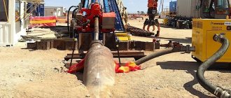
Exploration drilling is an effective way to determine the depth of a future well
The next step is to obtain permits if the drilling depth exceeds 30 m. However, the first impermeable layer rarely lies deeper. But you shouldn’t relax: the well will need a document - a passport, which indicates all the parameters of the source.
If the hydraulic structure was drilled independently, obtaining a passport is impossible and additional difficulties will arise in case of operational problems. To avoid this, as well as to accurately determine the drilling location, depth and potential power of the source, it is recommended to use the help of specialists in the installation and launch of hydraulic structures.
Professionals will perform a full range of work and share recommendations for effective operation. The source will last a long time and will regularly supply water, no matter how deep the aquifer is.
Pottery for determining the aquifer
To detect the location of the aquifer, previously dried earthenware is used. In dry weather, it is left upside down on the site overnight. If there is a water carrier located below in the soil, then by morning moisture will appear on the inner surface of the clay container.
An improved method can be used:
- Pour oven-dried silica gel into the dishes. It is recommended to use a clay pot.
- The container is covered with woven material and weighed, recording the indicator.
- The pot is buried to a depth of 1.5 or 2 m. Leave for a day.
- After 24 hours, the container is carefully dug out and weighed.
- The presence of nearby groundwater will be indicated by an increase in the mass of the pot.
By burying several containers in different places and at different depths, you can determine the maximum proximity to the aquifer.
Instead of silica gel, you can use crushed clay shards, ceramic bricks or crushed clay (after firing) as a filler.
Homemade depth gauge
This is the easiest way to determine the depth of a well or shallow well. It is implemented using a construction tape measure, a cord and a steel weight. Clear, dry weather is best for taking measurements in this way. Optimal dates are late summer, early autumn. The fact is that during this period groundwater is at its lowest level.
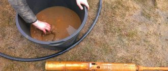
Tools for self-measuring well depth
Operating procedure:
- Determine the diameter of the well. A ruler is used for this. This will make it possible to select a suitable load.
- Lower the string with a weight at the end inside the shaft until the cord reduces its tension. This indicates contact with the bottom of the well.
- Pull the string out and lay it out in a straight line on the ground. By measuring the dry part, determine the distance to the water surface. To simplify the task, before starting the procedure, the cord is equipped with colored ribbons at the same distance.
- The size of the wet section of the string will indicate the volume of the source well.
Measuring the depth of the well using string and sinker
The main disadvantage of this simple method is the significant limitations on the measured depth (no more than 10 m).
In addition, the dimensions of the wet area indicate only the static level of the well, while when installing a pump it is necessary to know the dynamic level. To determine it, a suction hose with a filter at the end is threaded inside the casing: it must reach the bottom. By turning on the pump, time the time until the water supply is completely emptied. You need to turn off the pump only after specific squelching sounds appear. After this, the depth measurement procedure is repeated again: the height of the remaining water is the dynamic level.
Plants as an indicator of the aquifer
This method is used only in undeveloped areas where wild plants are present. The peculiarities of their location near groundwater are determined by the length and type of rhizomes.
Black poplar grows in areas with water up to 5 meters deep.
The depth of occurrence can be determined by the following crops:
- Within 1 m - wild rosemary, downy birch and cattail.
- From 1 to 3 m - wheatgrass, sandy reed and buckthorn.
- Up to 5 m - blackberry, sarsazan, raspberry, oleaster, blackberry, reed, spruce and black poplar.
- Within 7 or 8 m - pine, pedunculate oak, paniculata wormwood, bird cherry, heather and glossy cherry.
- From 3 to 10 m - juniper, cornflower, hazel, licorice, beech, bearberry and sand wormwood.
- Up to 15 m - yellow alfalfa.
In the case of trees, you should pay attention not to masses, but to individual plants. Sometimes trees grow in small groups in areas where the aquifer is located. In the case of herbs, what matters is the presence not of single plants, but of clearings on the site.
You should not focus on annual plants and ferns.
Scheme
Groundwater diagrams are drawn up by hydrogeologists. There may be several varieties of them in one limited area.
Surface waters in the diagram include the water level and soil waters. The capillary fringe and rise are water penetrating to the surface through tiny cracks in the rocks.
The diagram shows a non-pressure version with a mirror (reservoir) . In addition, 2 aquitards are shown separating groundwater and interstratal water.
Natural phenomena
Natural phenomena will help determine the location of the aquifer. Please note the following:
- When groundwater occurs, the soil is characterized by increased humidity.
- A large amount of dew forms on the site in the morning. The presence of fog in the morning is typical.
- When the air temperature rises under the influence of the sun, abundant evaporation is observed in the area.
- Above the aquifer, the grass grows thicker, has a brighter shade, and is fresher.
- A reliable indicator of the presence of water is the accumulation of anthills.
- Field mice do not make burrows in wet soil or near water sources.
- Chickens choose dry places to lay eggs, geese choose areas with high humidity.
- Midges are moisture-loving insects. In hot weather and in the absence of precipitation, midges swarm near the water carrier.
Productive aquifers are often located close to surface water. A good place for drilling a well will be an area 15 or 20 m from the river bed. In this case, the frequency of filling it with water does not matter.
Geese lay eggs in moist soil.
Water quality and pressure depending on well depth
The great depth of a well does not mean that the liquid produced with its help will be perfectly clean and saturated with the necessary microelements.
The composition of aquifers plays a major role in water quality. The strong pressure under which the liquid is located increases the solubility of all beneficial and harmful microelements in it. Therefore, the environmental situation in a given region plays a big role in quality.
Poor-quality connection of pipes with your own hands when installing a well will allow contaminants that are in the upper layers to enter the water. These can be various nitrates, pesticides, pesticides, etc. This error will spoil the quality of water obtained at a depth of even more than 500 meters.